Skip to main content
Mobile Response (iOS): Release Notes August 2026 (iOS Version 6.1.1)
New Features
Automatic Incident Command Template Selection
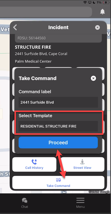
- What - Enhanced the Take Command workflow so the iOS application automatically selects the Incident Command template mapped to the dispatch's incident type when an applicable template is available. If no mapped template exists, users can continue using the existing manual template selection workflow.
- Why - Automatically loading the appropriate Incident Command template reduces setup time when establishing command and provides greater consistency between mobile and web workflows.
- How
- Open a dispatched incident.
- Select Take Command.
- If an Incident Command template is mapped to the dispatch's incident type, it is automatically selected.
- If no mapped template is available, select the appropriate template manually using the existing workflow.
- Use Case - A responder taking command of a structure fire can begin with the correct Incident Command template already selected, reducing manual setup and helping command operations get established more quickly.
Feature Enhancements
Offline Layer Auto-Zoom
- What - Improved offline map behavior so enabling a map layer while offline automatically adjusts the map to the layer's configured minimum zoom level when necessary. This allows the selected layer to become visible immediately instead of requiring the user to manually determine the correct zoom level.
- Why - Offline users may not know the minimum zoom level required for a particular layer to display. Automatically positioning the map at an appropriate zoom level makes offline map workflows more intuitive and reduces unnecessary interaction.
- How
- Enter Offline Mode using previously downloaded map data.
- Enable the desired map layer.
- If the map is currently outside the layer's supported zoom range, the application automatically adjusts to the minimum required zoom level.
- The selected layer then becomes visible when applicable.
- Use Case - A responder working without connectivity enables the hydrant or preplan layer and is automatically moved to an appropriate zoom level so the available offline information can be viewed immediately.
Fixes
Location Update Logging Crash
- What - Fixed a production crash that could occur during frequent GPS location updates when date-formatting resources were repeatedly created during location logging.
- Why - Location updates occur frequently during responder workflows, and improving the stability of this high-frequency process reduces the risk of unexpected application interruptions while unit positioning is active.
- How
- Continue using responder location and tracking workflows normally.
- Location update logging now uses the corrected processing behavior automatically.
- No user action or configuration is required.
- Use Case - A responder traveling to an incident with location tracking active can continue reporting position updates without encountering the previously identified crash during repeated GPS callbacks.
Avatar Image Rendering Crash
- What - Fixed a crash that could occur when user avatar images were resized outside the appropriate main-thread rendering context.
- Why - Properly handling avatar rendering improves application stability on screens where personnel or user images are displayed.
- How
- Continue using workflows that display responder or user avatars.
- Avatar images are now processed using the corrected rendering behavior.
- No configuration changes are required.
- Use Case - A user opening a screen containing multiple responder avatars can view personnel information without the application unexpectedly closing during image processing.
Dispatch Alert Synchronization Crash
- What - Fixed a crash in dispatch alert synchronization caused by an asynchronous operation not completing correctly when cancellation occurred.
- Why - Reliable alert synchronization is important for ensuring responder information updates correctly while avoiding application crashes during interrupted or changing workflows.
- How
- Continue receiving and reviewing dispatch alerts normally.
- Alert synchronization now safely handles cancellation conditions.
- No user action is required.
- Use Case - A responder navigating away from an incident while alert information is still synchronizing can continue working without triggering the previously identified asynchronous processing crash.
Missing Incidents on Poor Connections
- What - Fixed an issue where newly received incidents could remain missing from the Incidents List during poor or unstable network connectivity until the user manually refreshed the screen.
- Why - Responders need confidence that newly received incidents will appear without requiring additional manual actions, particularly when operating in areas with inconsistent connectivity.
- How
- Continue using the Incidents List normally.
- Newly received incidents are now handled more reliably during degraded network conditions.
- Manual refresh remains available but should no longer be required for this condition.
- Use Case - A responder operating in an area with weak connectivity receives a new dispatch and sees the incident appear in the list without needing to manually refresh the application.
Incident Icons After Dispatch Notification
- What - Fixed an issue where incident icons could fail to appear on the map after a dispatch notification was received.
- Why - Incident icons provide an immediate visual reference for dispatched locations, and missing markers can reduce situational awareness during response.
- How
- Receive a dispatch notification.
- Open or review the Responder Map.
- The associated incident icon now appears automatically when the dispatch is processed.
- No user configuration is required.
- Use Case - A responder receiving a new call can immediately identify the incident location on the map without performing a manual refresh to make the icon appear.
Newly Opened Incident Map Location Accuracy
- What - Fixed an issue where a newly opened incident could display the wrong map location or fail to display its incident icon until the application was refreshed.
- Why - Accurate incident positioning is essential for response navigation and situational awareness. The map should immediately reflect the incident currently being viewed.
- How
- Open a newly received incident.
- View the associated map information.
- The correct incident location and icon now display automatically.
- No manual application refresh is required.
- Use Case - A responder opening a newly dispatched incident immediately sees the correct location and marker, allowing navigation and response planning to begin without additional steps.
Dispatch Message Timeout Error
- What - Fixed an issue where users could receive a timeout-style error after sending a dispatch message even though the message had actually been transmitted successfully.
- Why - Displaying an error after a successful action can cause users to resend messages unnecessarily or question whether important information was delivered.
- How
- Create and send a dispatch message using the existing workflow.
- Successful messages now complete without incorrectly presenting the timeout-style error.
- No additional configuration is required.
- Use Case - A user sends an operational dispatch message and receives accurate confirmation behavior rather than an error suggesting the successful message may have failed.
Partial Offline Download Cleanup
- What - Added cleanup handling for incomplete offline map and client-data downloads left behind after interruptions such as logout, account switching, application termination, or relaunch.
- Why - Partial downloads can leave confusing or unusable offline data on the device. Cleaning up incomplete artifacts helps maintain a more predictable offline experience and prevents invalid data from affecting future downloads.
- How
- Download offline map or client data using the normal workflow.
- If the download is interrupted by logout, account switching, application termination, or relaunch, incomplete data is automatically identified and cleaned up.
- Start a new download when needed.
- No manual file cleanup is required.
- Use Case - A responder begins downloading offline data and the application is closed before completion. When the application is reopened, the incomplete data is removed so a clean download can be started.
Preplan Attachment Session Timeout Handling
- What - Fixed session timeout behavior so viewing attachments from the Preplan Dashboard no longer incorrectly activates the application idle timer when the workflow should remain exempt.
- Why - Users reviewing preplan attachments may remain on the same content for an extended period. Incorrectly treating that activity as idle could interrupt the workflow with an unnecessary session timeout.
- How
- Open the Preplan Dashboard.
- Select and review a preplan attachment.
- The attachment workflow now follows the correct session timeout behavior.
- No user configuration is required.
- Use Case - A responder reviewing a detailed preplan document for several minutes can continue reading without the application incorrectly treating the session as inactive and starting an unnecessary timeout.
Map Layer Preference Permission Handling
- What - Fixed map-layer preference synchronization so users without permission to update preferences no longer send restricted preference changes to the server.
- Why - This correction ensures mobile behavior respects assigned permissions and prevents unauthorized preference updates from being submitted through map interactions.
- How
- Continue using map-layer controls normally.
- Users without the required update permission can interact with supported map functions without restricted preference changes being synchronized to the server.
- Users with the appropriate permission continue using preference synchronization as expected.
- Use Case - A responder without administrative preference permissions can adjust map visibility during their workflow without unintentionally changing organization-managed settings.